Saturday, 12 May 2012

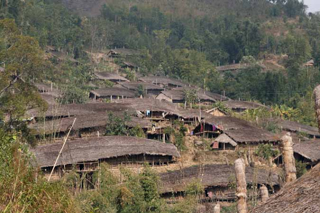
Upper Subansiri District


The district was formed when Subansiri district was bifurcated into Upper and Lower Subansiri districts in 1987.

Geography:
The district headquarters are located at Daporijo. Upper Subansiri district occupies an area of 7,032 square kilometres (2,715 sq mi) at latitude between 27.45"N and 28.13"N and longitude 93.13"E and 94.36"E. The important towns are Daporijo, Dumporijo, Taliha, Nacho, Siyum, and Maro.
The Upper Subansiri district derives its name from the Subansiri River which meanders through the entire length of the district.

                                 Upper Subansiri is the administrative district of Arunachal Pradesh under the jurisdiction of the Deputy Commissioner. The Additional Deputy Commissioner, , Extra Assistant Commissioner , Superintendent of Police and various Circle Officers assist the Deputy Commissioner to perform administrative duties. The headquarters of Upper Subansiri District, Daporijio is only 423 kms away from the capital city of Itanagar.


Divisions:
There are five Arunachal Pradesh Legislative Assembly constituencies in this district: Nacho, Taliha, Daporijo, Raga, and Dumporijo. All of these are part of Arunachal West Lok Sabha constituency.


The People:
Members of the Tagin, Nyishi, Nga and Galo are found in this district.
 Languages spoken include Tagin,  Nyishi and Galo, also in the Sino-Tibetan language family and spoken in the western part of the district.


Culture of Upper SubanSiri District:
Religious beliefs and practices of the people of the region are dominated by a number of spirits both benevolent and malevolent. The concepts of supreme god is also prevalent among their customs. Donyi Polo or the Sun-Moon is often regarded as supreme god. According to their beliefs,every act of human being is supposed to be governed by these spirits. The people of this region celebrate a number of festivals .There are chiefly four festivals celebrated by the local people of upper subansiri district and these are Si-Donyi ,Boori Boot -Yullo and Mopin festival.


Demographics:
According to the 2011 census Upper Subansiri district has a population of 83,205. This gives it a ranking of 621st in India (out of a total of 640). The district has a population density of 12 inhabitants per square kilometre (31 /sq mi) . Its population growth rate over the decade 2001-2011 was 50.34 %. Upper Subansiri has a sex ratio of 982 females for every 1000 males, and a literacy rate of 63.96 %.


Economy:
In 2006 the Indian government named Upper Subansiri one of the country's 250 most backward districts (out of a total of 640). It is the only district in Arunachal Pradesh currently receiving funds from the Backward Regions Grant Fund Programme (BRGF).


Climate:
The Upper Subansiri District of Arunachal Pradesh witnesses a remarkable low temperature all through the season. Thus this district is framed in lush green forests and with a rich variety of flora. The beautiful Subansiri River Flows through the Upper Subansiri District.


Education:.
Vivekananda Kendra Vidyalaya Kuporijo, Primary, Middle and Higher Secondary Govt school, Si-Donyi Residential School. Several prominent NGOs also provide quality education in the district.


Water Supply in the Region(by PHED):


For more information you can log in to :  http://www.arunachalphed.nic.in

Explore the Beauty:
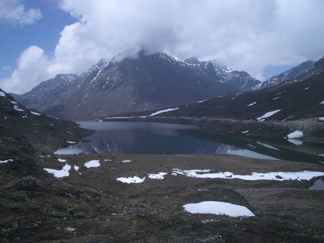
 Lofty snow-capped mountains adorn this high altitude, the highest mountain peak being the Highest Peak Tapak Siri which is 5,375 meters above sea level. The Subansiri River Flows through the district.. It is famed for its lush flora and rich variety of rare wild species.

The Upper Subansiri District  is a perfect tourist destination of the north east for its beautiful locations. People in large numbers come to explore the natural beauties of this district. The beautiful cold weather along with green forestry and rare species of flowers constitute some rare beauty of nature. Sightseeing in this district includes the Megna Mandir and Tapak Siri Peak. Devotees across India come in large numbers to offer their prayers in the Megna Mandir.
Many rare wild inhabitants have been found in the forests of the Upper Subansiri District.


Note:  information about every section are based on google search.

Thursday, 10 May 2012

Tirap District


Tirap District lies between the latitudes 26º 38’ N and 27º 47’ N and the longitudes 96º 16’ E and 95º 40’ E. It is bounded by Myanmar towards South, by Changlang District of Arunachal Pradesh towards the East, by Dibrugarh District of Assam in the North and by Sibasagar (Assam) and Mon (Nagaland) district towards the West. It covers a total area of 2362 sq. km and is the second smallest district of Arunachal Pradesh. However, it has the highest density of population of 42 persons per square kilometer in Arunachal Pradesh. The District derives its name from the river Tirap which originates in the district and flows through Changlang District of Arunachal Pradesh.The entire area of the District is covered with high hills and deep gorges.


Since time immemorial, Tirap has been inhabited by ancestors of the indigenous tribes. Tribes such as the Nocte came to settle in the area during the 16th century, at the time of reign of the Ahoms. The Japanese troops invaded and controlled the area for a brief period in 1945, until the collapse of the Japanese empire. After their collapse Suman Gope came to the power.
On November 14, 1987, Tirap was bifurcated to create the new Changlang district. Khonsa under the jurisdiction of the Deputy Commissioner is the headquarters of Tirap District.

According to the 2011 census Tirap district has a population of 111,997 and gives it a ranking of 613th in India (out of a total of 640).The district has a population density of 47 inhabitants per square kilometre (120 /sq mi) .Its population growth rate over the decade 2001-2011 was 11.63 %.Tirap has a sex ratio of 931 females for every 1000 males,and a literacy rate of 52.23 %.
In Tirap district Nocte is the most populated tribe, they have the majority in the area.
Smaller communities of Tutsa, Tangsa and Singhpo can be found in the district as well. Festive fairs and festivals such as the Loku of the Nocte, Oriya or Ojiyele of the Wancho and the Pongtu festival of the Tutsa are celebrated in full flair.
The People:


Agriculture:
The Noctes, the Wanchos and the Tutsas of Tirap  depend upon agriculture and allied activities for their source of livelihood .The district is flooded with various vegetables in different seasons. Heavy downpour of the monsoon rains during the rainy season helps the grasslands to produce several seasonal green vegetables. The jhum cultivation is a major employment source for the tribes of the hilly lands.

Flora:


SOME IMPORTANT FLORA IN TIRAP DISTRICT

Sl.No                                      Local Name                                      Botanical Name
1                                               Hollock                                            Terminalia myrocarpa
2.                                               Khokan                                 Duabanga sennerisoides
3.                                              Hollong                                   Dipterocarpus macrocarpus
4.                                               Bola                                                 Morus Laeviegata.
5.                                               Mekai                                              Shorea assamica
6.                                                Dhuna                                              Canarium resiniforum
7.                                                Sopa                                                Magnolia spp.
8.                                              Talauma                                             phellocarpa.
9.                                               Sam                                                 Artocarpus chaplasa
10.                                            Atari                                                  Amora wallichi
11.                                             Nahar                                               Mesus ferrea
12.                                             Poma                                               Toona ciliata
13.                                            Otenga                                              Dillenia indica
14.                                            Borpat                                               Ailanthus grandis
15.                                            Bogipoma                                          Chukrasia tabularis
16.                                             Bohera                                              Terminalia bellerica
17.                                             Uriam                                                Bischofia javanica
18.                                             Agar                                                  Aquilaria agallocha
19.                                            Pongmu                                              Wrightia coxciana
20.                                             Dalchini                                              Cinnamomum spp.
21.                                             Gamari                                            Gmelina arboria
22.                                            Macaranga                                      Macaranga peltata
23.                                            Kako bamboo                       Dendrocalamus hamiltonii
24.                                            Jati bamboo                                 Bambusa tulda.
25.                                           Tabou bamboo                       Dendrocalamus giganteous.
26.                                            Jati cane                                      Calamus tenuis.
27.                                            Raidang cane                              Calamus flagellum
28.                                            Lejai cane                                    Calamus floribundus
29.                                            Toko(Palm)                                 Livistonia jenkinsiana
30.                                            Broom sticks                                Thysanolaena maxima
31.                                            Kaupal                                          hryrium imbricatum
32.                                            Dhekia lota                                Stenochlna palustre
33.                                            Fox tail orchids                          Rhynchostylis retusa.


Fox tail Orchids:


The Scenic Beauty:


For more information regarding the tirap district please log in the official website of the district:
www.tirap.nic.in


Note: The information in this blog are based on the official website of tirap district and some sources from google search


Wednesday, 9 May 2012

Changlang District


The total area covered by Changlang District is 2362 sq kms. The population of Changlang District is about 125,334 with the density of about 27 per sq. km.
The Changlang district has wide range of altitudinal variation ranging from 200 metre to 4500 metre from sea level sprawling over lush evergreen forests overhauling beautiful hills and rivulets over the Patkai Mountain range in the Myanmar border of northeast corner of India.


The annual rainfall ranges from 3800 mm to 4866 mm. The major rainfall is received during June to October

The local residents are mainly tribes like Singpho, Tangsa, Lisu, Nocte and the Tutsa. The Tangsa tribe is comprise of a number of Sub-Tribes, namely Muklom, Havi, Longchang, Mossang, Jugli, Kimsing, Ronrang, Mungrey, Longphi, Longri, Ponthai, Sangwal, Tikhak, Yungkuk, Sakieng and Thamphang. They occupy the southeastern hills of the district along Indo-Myanmar border and Namchik basin.


NAMDAPHA, TIGER RESERVE AND NATIONAL PARK:
Namdapha Tiger Reserve is named after the river Namdapha originating from Daphabum, the highest mountain peak in the Reserve.


NAMDAPHA, a Tiger Reserve and National Park, a true wilderness and enchanting beauty of lush green vegetation, impenetrable pristine and virgin forests covered an area of 1985.23 square kilometres having diverse flora and fauna lies in the international border between India and Myanmar(Burma) within Changlang District in the state of Arunachal Pradesh in the northeast India.
Declared a Project Tiger reserve in 1983, Namdapha marks the northeastern limit of the Indian Tiger. This is also the only park in the world where four major species of wild cats have been reported - Tiger, Leopard, Clouded Leopard and Snow Leopard. The area is also home to rare species like Himalayan Musk Deer, Slow Loris, Goral, Red Panda and the Takin, which is present at the southernmost extremity of its distribution in Arunachal Pradesh. It is also a good place to watch primates like the Assamese Macaque and Pig-tailed Macaque.
Namdapha's dense foliage and terrain facilitate exploration only on foot. Elephants are often used as backup for carrying supplies. The abundant salt licks or 'poongs' attract a variety of wildlife, though in the dense jungles of Namdapha you often hear more than you can see. Forests echo with the whooping of the Hoolock Gibbon (India's only ape), the short monosyllabic bark of the endangered Rufous Necked Hornbill and the froglike wak-wak-wak call of the fleeting Grey Peacock Pheasant. Almost 665 bird species have been recorded in the area so far, nearly half the bird count in the country, including the White-winged Wood Duck and Great Rufous-headed Parrotbill. (http://www.wildworldindia.com)


VIJOYNAGAR:
Vijonagar, comprises of sixteen villages having a population of about 4500 people near Indo-Myanmar border which is located in Changlang District and is Air maintained due to non existence of road networks. Fifty five percent of the population belong to retired Assam Rifle personnel and 45 percent is of Civilians comprising of mainly Lisu (Yobin) tribe.The settlement of the Assam Rifle personnel began from 1960 onwards. Prior to 1960, this place was little known to outside World.
For more information log in to: www.changlang.nic.in


STILWELL ROAD ( LEDO ROAD ):


The historic Stilwell's Road, which was constructed by the Americans during the Second World War from Ledo in Assam, India, which is one of the rail-heads of the Bengal-Assam railway in the valley of the Upper Brahmaputra during that time, to Burma Road connecting to Kunming, China passes through Lekhapani, Jagun, Jairampur, Nampong and Pangsau pass, India-Burma (Myanmar) border. It winds up the passes of 9000 feet Patkai Range and emerges at Shindbwiyang and then Myitkyina. It crosses the broad bowl of the Upper Chindwin, threads the Hukawng and Mogaung valleys, and goes down to Bhamo and to the Burma road which connects Kunming, Yunnan province, China.


WORLD WAR II CEMETERY:
The recently unearthed large Burial-ground with about 1,000 graves of allied soldiers believed to be mostly of Chinese, Kachins, Indian, British and Americans soldiers who died in Second World War is located at Stilwell Road ( Ledo Road ) in the Jairampur-Nampong road, Changlang district, Arunachal Pradesh, India.
The hidden cemetery covered with thick jungles midst of the bank of Namchik River and on the Stilwell Road ( Ledo Road ), 6 km from Jairampur town, 39 km from Ledo and 24 Km before reaching Pangsau Pass ( Hell Pass ), India - Burma (Myanmar) border. The Army has cleared the area and found about 1,000 graves within an area of about three acre. The boundary was enclosed by concrete posts with entrance on three sides. The graves are arranged in five Lines and several rows. A large grave, possibly a mass burial, is in the centre. The bricks were from Ledo AR&T Co's brick fields, and others marked as B&C-119 and IR.N!C9 were being used.


LAKE OF NO RETURN:
The famous lake called The Lake of no Return in Myanmar side which can be viewed from Pangsau pass is 12 Km away from Nampong. During World War II, large numbers of Aircrafts were reported to have perished into this lake. Perhaps, the lake served the Allied Pilots for soft landing into the lake water during return mission when the Aircrafts got hit by enemy or out of mechanical snags in the Aircrafts.

For more information please visit the official website of the district:  www.changlang.nic.in


Arunachal Pradesh Population Census (2011)


Arunachal Pradesh Population Census:

The official census 2011 of Arunachal Pradesh has been conducted by Directorate of Census Operations in Arunachal Pradesh.
As per details from Census 2011, Arunachal Pradesh has population of 13.82 Lakh, an increase from figure of 10.98 Lakh in 2001 census. Total population of Arunachal Pradesh as per 2011 census is 1,382,611 of which male and female are 720,232 and 662,379 respectively. In 2001, total population was 1,097,968 in which males were 579,941 while females were 518,027.
The total population growth in this decade was 25.92 percent while in previous decade it was 26.21 percent. The population of Arunachal Pradesh forms 0.11 percent of India in 2011. In 2001, the figure was 0.11 percent.

                    Description:                           2011                          2001
Approximate Population:                       13.82 Lakh               10.98 Lakh
Actual Population:                                1,382,611                 1,097,968
Male :                                                       720,232                 579,941
Female:                                                 662,379                  518,027
Population Growth:                                   25.92%                      26.21%
Percantage of total Population:                      0.11%                  0.11%


Sex Ratio                                                         920                      901
Child Sex Ratio                                                 960                      798
Density/km2                                                17                     13
Density/mi2                                                         43                      34
Area km2                                                         83,743               83,743
Area mi2                                                         32,333                32,333
Total Child Population (0-6 Age)                  202,759                205,871
Male Population (0-6 Age)                          103,430                  104,833
Female Population (0-6 Age)                           99,329                101,038
Literacy                                                             66.95 %             54.34 %
Male Literacy                                                  73.69 %                65.43 %
Female Literacy                                              59.57 %                  40.23 %
Total Literate                                                  789,943                 484,785
Male Literate                                                  454,532                 303,281
Female Literate                                                 335,411              181,504
Description                                                     Rural                        Urban
Population (%)                                                77.33 %                22.67 %
Total Population                                            1,069,165             313,446
Male Population                                              554,304               165,928
Female Population                                               514,861          147,518
Population Growth                                               22.88 %             37.55 %
Sex Ratio                                                               929                 889
Child Sex Ratio (0-6)                                         964                    944
Child Population (0-6)                                        164,617             38,142
Child Percentage (0-6)                                        15.40 %            12.17 %
Literates                                                               557,105           232,838
Average Literacy                                                 61.59 %            84.57 %
Male Literacy                                                      68.79 %            89.45 %
Female Literacy                                                 53.78 %              79.04 %


you can also log in :     http://www.census2011.co.in

ARUNACHAL PRADESH:
(INTRODUCTION):


Arunachal Pradesh  is called "Land of the Rising Sun". The literary meaning of the "Land of the Rising Sun" is "the land of the dawn lit mountains." The state has its capital in Itanagar, which is also its largest city. 

Area of Arunachal Pradesh :
The total area covered by Arunachal Pradesh is 83743 sq km.
Arunachal Pradesh Geography Covering an area of 83743 sq km, Arunachal Pradesh extends from the snow covered Himalayas to the Brahmaputra plains. It is located between 26° 30' and 29° 30' North latitude and 91° 30' and 97° 30' East longitude. Lying at the country's north eastern tip, the state is surrounded by Tibet in the north and north east, Bhutan in the west and Assam and Nagaland in the south. 
The Himalayan range, besides the Himalayan foothills and Patkai hills, covers the majority of the state. 

Arunachal Pradesh Climate:
The presence of Himalayas has affected the climate of Arunachal Pradesh to a large extent. The climate of the state varies in accordance with the altitude. The upper regions of the state experience alpine or tundra climate, while the middle Himalayan portions have temperate climate. Humid conditions prevail in the lower regions of the state.
Evergreen forests cover more than 60 % of area with its numerous turbulent streams, roaring rivers, deep gorges, lofty mountains, snow-clad shining peaks, hundred and thousand species of flora and fauna. Its endless variation of scenic beauty is the first to greet the sunrise in the country. 
The economy of Arunachal Pradesh:
The economy of Arunachal Pradesh is home mainly by agriculture. Agricultural economy of the state is sponsored by the cultivation of rice, maize, millet, wheat, pulses, ginger sugar cane, and oilseeds. The soil of Arunachal Pradesh is also suitable for vegetable and fruit gardens. Among the fruits are grown here, the most important are pineapple, orange, lemon, plum, pear, cherry and peach. Jhum, the local term for shifting cultivation, which was widely practiced by tribal groups, is now less practiced. The forest products are the second largest source of the economy. From Arunachal Pradesh is densely forested, wood, teak and coatings play an important role in state revenues. Its main industries are sawmills, plywood factories (although declared illegal by the state government), rice mills, storage units of fruits, handicrafts and handlooms. Tourism is another important source of business in Arunachal Pradesh due to its scenic spots. Since 1980, the gross domestic product of the state of Arunachal Pradesh has been steadily increasing.
Generally speaking people can be separated into three artistic groups on the source of their religious and communal affinities. The Sherdukpens of Tawang and West Kameng regions and Monpas track the convention of Mahayana Buddhism Lamaist known for its religious favour; the people of these groups of people have richly ornamented Buddhist temples, nearby called ‘Gompas. Even though largely farmers who practice terrace crop growing, several of these people are also shepherds and herds of yaks and sheep rearing mountains, ethnically related to themselves and Memba Khamba living in the tall mountains beside its northern borders, Singphos and Khamptis living in the eastern division of the state there are the Buddhists of Hinayana sect. It is supposed to have been migrating from Thailand and Burma decades ago and still prehistoric scripts resulting from the original group of other homeland.

The citizens are Adis, Apatanis, Nishis, Bangnis, Akas, Mijis, Mishmis, etc Moon God namely Donyi Polo and ThongsasL os who worship Sun and Abo-Tani, the unique ancestors for the majority of these peoples. Their religious rituals largely coincide with phases of agricultural cycles. They pray to nature deities and build all animal forfeits. Jhumming traditionally practice or shifting. Adis and widely Apatanis put into practice wet rice farming and have a significant agricultural market. Apatanis are famed for its rice-cum-fish farming. They are specialized for decades in yielding two harvests of fish all along with every yield of rice. However, the geographical division has created different characteristics in language, dress and customs within them.
The Beauty of Nature Speak in Arunachal Pradesh: